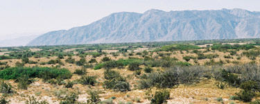
The desert and dunes near Yuha Wells offer
a stark contrast to the cactus-filled deserts near Tubac and Tucson.
Photo: NPS
Driving Directions for Auto Route
Continuing on the auto route from Yuma
County, at Yuma, Arizona, the historic route dips into Baja
California, Mexico, and then turns north through the California
desert on Bureau of Land Management land to arrive at the San Felipe
Wash. The auto route takes the driver from Yuma to the San Felipe
Wash on roads well east of, but parallel to, the historic route.
Follow I-8 west from Yuma to CA 98. In Calexico, turn north from
CA 98 to CA 111. At Heber Road, turn west on CA 86. Turn west on
CA 78 which parallels San Felipe Wash, the historic trail. The climate
of this route is one of the most extreme anywhere along the Anza
Trail. Summertime temperatures frequently reach over 120 degrees
for extended periods of time. To continue on the auto route, see
San Diego County.
Father Garcés and
a Native at Mission La Purísima Concepción.
Photo: Ron Ory
Fandango
For December
17, 1775, Father Font writes, "...At night, with the joy
at the arrival of all the people, they held a fandango here.
It was somewhat discordant, and a very bold widow who came
with the expedition sang some verses which were not at all
nice, applauded and cheered by all the crowd...the fandango,
which lasted until very late." Today, less than 10 miles away
at the Salton Sea, over 30, 000 white pelicans give visitors
an equally exuberant and flamboyant spectacle as they migrate
to the area each year. The Salton Sea International Bird Festival
in February celebrates over 380 species of birds.
Mission La Purísima
Concepción
Photo: Ron Ory
About
Your Visit to Imperial County
Anza followed the Colorado River south into what is now Mexico.
The 1775/76 colonizing expedition remained south of the present
border for several days to rest before crossing the desert
in three groups (plus a fourth with the cattle). They looped
back into what would become Imperial
County, California 132 years later. They then continued
north to the San Sebastian Marsh, turned west and followed
San Felipe Creek. (See the historical
background.)
Sites of Interest
A. Mission Purísima Concepción and Expedition
Camp #42
Expedition Camp #42 was just south of Pilot Knob. Along their
way, Font and Anza paused at a granite bluff to view the Colorado
River plain on December
4, 1775. Nearby, in 1780, Father Garcés founded
Mission Purísima Concepción, only to
have it destroyed by the Quechan uprising of July 1781. In
the process, Father Garcés, Fernando de Rivera y Moncada,
and many soldiers and settlers were killed. The mission site
(32°43.833'N 114°36.937'W) is probably where the St. Thomas
Indian Mission stands today (on Picacho Rd, Fort Yuma, 1 mile
South of Winterhaven).
B. Santa Olalla and Expedition Camps
#43-46 (Baja California)
Although these camps in Baja California are not part of the
Juan Bautista
de Anza National Historic Trail, they are marked as Ruta
Histórica (Hwy 2). Camp #44 (Santa Olalla) was
where Anza wrote a letter to Viceroy Bucareli during
the 1774
expedition, telling of its difficulties and the trustworthiness
of the Quechan and their chief (Palma). During the 1775/76
expedition, the second
fandango was held here, and Anza wrote five letters.
In one to Bucareli, he tells of two births, the one death,
and the expedition's difficulties. It was here that the local
natives (probably the Cocopah and Cajuenches tribes) gave
the colonists fish and watermelons which Anza thought improved
the health of those who were sick. It was also here that the
expedition split up into three groups to cross the desert
without depleting the watering holes.
C. Wells of Santa Rosa (Yuha Well) and
Expedition Camps #47 and #48 (See Father
Font's map in new window)
The well, called Santa Rosa de las Lajas (Flat Rocks)
by Anza, was used on March
8, 1774. On December
11-15, 1775, the three divisions of Anza's colonizing
expedition used this site as the first good watering spot
beyond the Colorado River. It is about 7 miles northwest of
Mexico's Mount Signal, on the southwest side of Dunaway Rd.
in the Yuha
Desert. California
State Historic Landmark No. 1008 plaque is found at the
Eastbound Sunbeam Roadside Rest Area, between Drew and Forrester
Rds., on I-8 near Seeley. The Vista
de Anza Historical Marker is found off Hwy 98 northwest
of Calexico, 6 miles south of Coyote Wells. Camp #48 was near
the Plaster City OHV (Off-Highway Vehicle) area.
D. San Sebastián Marsh/San Felipe
Creek and Expedition Camp #49 (See Father
Font's map in new window)
San Sebastián Marsh is the site of prehistoric
villages and represented a stable water source in the desert
environment. It was a campsite for both the 1774 and 1775-76
expeditions. Named
for Anza's Indian guide, Sebastián Tarabal,
it is located 18 miles northwest of Westmoreland in the vicinity
of the junction of state highways 86 and 78. Ironically, the
nearby Salton Sea, formed when a canal broke in 1905, is today
a 35 mile long desert oasis and includes a National
Wildlife Refuge.
Learning
On The Trail in Imperial County
Questions on the Trail
Sebastián
Tarabal was an American Indian from Baja California
who accompanied Portolá on his 1769 expedition.
He was later taken to Mission San Gabriel. He escaped
with his wife and another native across the desert,
reaching a frontier outpost of New Spain while Anza
was preparing to leave for his 1774 expedition. Anza
took Sebastián along with him as a guide. For
his help in crossing the treacherous desert, Anza named
camp #49 after him. Anza took Sebastián with
him again on this 1775-76 expedition, and left him at
the Yuma Crossing together with Fathers Garcés and Eixarch.
Sebastián later accompanied Father Garcés
on a remarkable trek to California through the Mojave
Desert and the Sierras during the same year. Anza called
him el Peregrino, the traveler/pilgrim.
Question: Name one American Indian who might be honored
in the Anza Trail Logo. From Yuma
County, name another.
Question: Did Sebastián Tarabal and Father Garcés
make it to Mission San Gabriel? To find out if Sebastián
was a witness at Maria Feliciana Arballo's wedding in
April 1776, see Los
Angeles County or this excerpt
from the book of marriages at Mission San Gabriel.
(The excerpt will open in a new window. Please close
that window when finished.)
Tiles outside Pacific House in Monterey
Photo:
Greg
Smestad
On the CD: Desert Fandangos
Cattle on the move (recorded on a Sinaloa Cattle
Drive); Chacona, "To the Good Life" by Juan Arañés (guitar);
Music for the Fandango: El Minuet de Cuatro (guitar)
The campsite for December
6-8, 1775 was at Santa Olalla south of Imperial
County in Baja California. When the herd of cattle
caught the sight and smell of the water at their destination,
they rushed for the water to drink. It was here that
the second Fandango was held. It was also where Anza
decided to divide the march through the desert into
three groups, plus a fourth consisting of the vaqueros
and the cattle.
The diaries do not record the music played during the
Fandangos. One can be sure that it did not include the
same religious music mentioned by Father Font. Perhaps
the highly popular Chacona, used in plays and in the
theatre in Spain during from the 16th century onward,
was imitated on whatever instruments were available.
After they crossed the desert, the third Fandango (December
17) was held at San Sebastián, a camp named
after Anza's Indian guide, Sebastián Tarabal.
Font later censures the young widow Feliciana Arballo
here for the lyrics of a song she sang while dancing.
Cocopah Indian Reservation - County 15th and Avenue G, Somerton
AZ 85350;
tel.: 928-627-1992,
web: cocopah.com
BLM El Centro Field Office -1661 South Fourth St., El Centro,
CA 92243;
tel.: 760-337-4400,
web: ca.blm.gov/elcentro
Salton Sea National Wildlife Refuge - 906 West Sinclair Rd.,
Calipatria, CA 92233 9744;
tel.: 760-348-5278,
web: fws.gov/saltonsea
Remember that entering the U.S. or Mexico without using a
port of entry is dangerous and illegal. For example, use the
Port of Entry at Mexicali or Algadones -
tel: 760-572-0089, and
tel.:760-768-2330,
web: cbp.gov