On November 14, Father Font noted, "On
leaving camp, we ascended a small sierra formed of boulders and black
rough rocks piled up, but thereafter, the country is level...We forded
it [the Gila River] without mishap..."
Photo: Ron Ory
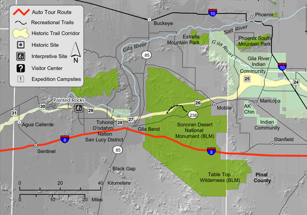
Driving Directions for Auto Route
Interstate 8 (I-8) is the auto route from Pinal
County. A combination of dirt and gravel roads, however, follow
the historic route more closely. These include highway 238 from
Mobile to Gila Bend and roads from Gila Bend past the Painted Rock
Petroglyph Site to Hyder. To reach the Painted Rock Petroglyph Site,
drive west on I-8 and exit at Painted Rock Dam Rd. (Exit 102) approximately
12.5 miles west of Gila Bend. Travel north (paved) 10.7 miles to
Rocky Point Rd. (unpaved). The site is 0.6 miles west of Painted
Rock Dam Rd. on Rocky Point Rd. To most easily continue to Yuma
County, travel west on I-8.
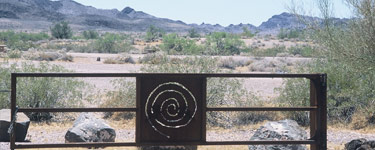
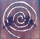
Petroglyph pattern
on a gate at the Painted Rock Petroglyph Site
Photo: Ron Ory
Gila People
Gila (Pronounced "hee-la") Bend, near a sharp bend in the
Gila River, is located near a prehistoric Hohokam Indian village.
In 1699, Father Eusebio Francisco Kino visited a ranchería
there, and it was again visited by Anza in 1774 and 1775.
Called both Opas and Cocomaricopas in the diaries, the natives
farmed wheat, maize (Indian corn), and calabazas (squash).
They call themselves Pipatsje, 'people,' Maricopa being their
Pima name, and spoke a language related to the Yuma, but had
been at war with them. They allied themselves with the Pima
(Gila River O'odham) whose language they could not understand.
To this day, this alliance has remained, and many people of
Maricopa descent reside with the O'odham.
Washing clothes
Graphic: David Rickman
About
Your Visit to Maricopa County
Leaving Laguna del Hospital, the expedition traveled
west through lands of the Opa and Cocomaricopa peoples. They
left the Gila River to bypass its large bend to the north,
rejoining the river again in the vicinity of Gila Bend. Renewing
Anza's friendship with the natives along the river, Anza and
the colonists followed the Gila River to Agua Caliente.
Sites of Interest
A. Gila Bend and Expedition Camps #26-28
At about one in the afternoon on November
7, 1775, the expedition left their "Lake of the Hospital"
and made a tardeada west to a dry arroyo (Camp
#26). A tardeada was two short marches between two
places that had water that could not be made in one normal
day's travel. The encampment for the night between the two
spots (in this case, Camp #26) was without water other than
what they were carrying. Anza remarked that their camp was
in the neighborhood of the Pass of the Cocomaricopas. Today,
west of this camp and somewhat parallel to Highway 238, the
Sonoran
Desert National Monument (BLM) has a trail where one can
hike a portion of the second stage of the tardeada.
On the 8th of November, the expedition camped at a village
they called San Simón y Judas de Uparsoytac (Camp #27).
They rested here until November 11, in part because a woman
who had a stillborn baby (on November 2) needed rest. This
gave the colonists time for some needed chores, as recorded
by Font, "...Since we were camped on the bank of the river,
the people were able to wash their clothing." While there,
and again further on, Anza noted seeing more American Indians
than during his first visit (1774), and attributed this to
the peace with the Yuma people (Quechan)
he helped secure during that time. Expedition Camps #27 and
#28 were most likely located within the Gila Bend Indian Reservation,
home today to the San Lucy District of the Tohono
O'odham. Fortaleza, an important spiritual site, is
located on top of a volcanic escarpment on the reservation
in the vicinity of the town of Gila Bend. The site was probably
settled about 1200 A.D. by migrants from the Tucson area,
and contained three large reinforced adobe ceremonial chambers
and rooms grouped in social units of two or three houses.
B. Petroglyph Site and Expedition Camps
#29-31
The expedition continued west camping at three villages of
the Maricopa peoples the last they called Agua Caliente,
for the hot spring of water there. Here, Anza selected a native,
he called Carlos, as Governor of the Cocomaricopa tribe (Maricopa)
who later traveled with the expedition to verify the peace
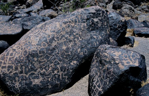
with the tribe in Yuma. Today, the Painted
Rock Petroglyph Site (BLM land) is within the expedition's
historic corridor. The site, on the National Register of Historic
Places, offers a fine example of early petroglyphs etched
on a small mound of black rocks. It also includes interpretive
panels on the Anza Trail, as well as camping and water. Many
other trails were near the petroglyph site, including those
of the Mormon Battalion and the Butterfield Overland Mail.
Near expedition Camp #31, an Interstate 8 roadside rest stop
at Sentinel provides an opportunity for visitors to reflect
on the Agua Caliente camp and to orient oneself to the Gila
River camps.
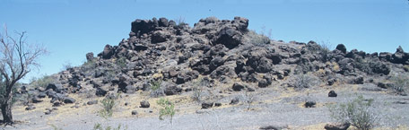
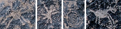
Enlarged details from
Painted Rocks
Photo: Ron Ory
Learning
On The Trail in Maricopa County
Questions on the Trail
The spirals and other patterns on the black rocks
at the Painted Rock Petroglyph Site are also seen
at other sites from Mexico to Northern California.
Nearby Gila Bend was a stopping point for the
1846 Mormon Battalion Trail and for the Stagecoach
line.
Photo: Ron Ory
Question: Why has the Gila River area been an important
migration route for thousands of years? [Hint: What's
special about the area?]
Question: What did Father Font say about the temperature
of the water at Agua Caliente? To find the answer, go
to the Calendar
of Father Font's diary and click on Wednesday, November
15.
Heard in Maricopa: The Cocomaricopa
In Maricopa county at Agua Caliente (which is
still known by that name today) Anza selected a Governor
and Acalde from the Cocomaricopa tribe
[Maricopa]. Father Font writes on Wednesday, November
15, 1775, "It was decided to halt here today in
order that the saddle animals might rest, for they were
now in very bad shape for lack of pasturage. Many Cocomaricopa
Indians assembled to see us. They are the same as the
Opas, but are distinguished in name by the district
which they inhabit. The commander, in the name of the
king our sovereign, gave the cane and title of governor
of all the tribe to an Indian whom they themselves elected
and whom we called Carlos, and to another, chosen by
them and called by us Francisco, he gave the cane of
Acalde. After they were instructed in their new
charges and duties, and as soon as they were confirmed
in their offices, the rest of the Indians assembled,
saluted them in turn, and shook hands with them, and
then a distribution of tobacco and glass beads was made
to all...The Indians whom I saw assembled here I estimated
at about two hundred souls, all unarmed and friendly.
They remained until after midnight singing in their
key, which is very funereal." Indian Lands that the
Maricopa are on today are within the Gila River and
AK-Chin Indian Communities.
Additional Resources
Bureau of Land Management (BLM)
Phoenix Field Office Lower Sonoran Field Office
21605 N. 7th Ave.,
Phoenix, AZ 85027;
tel.: 623-580-5500,
web: blm.gov/az/
st/en/fo/lower_
sonoran_field.html
Painted Rock Petroglyph Site
tel.: 623-580-5500,
web: blm.gov/az/
Tohono O'odham San Lucy District, Gila Bend Reservation -
P.O. Box 837 Sells, Arizona 85634;
tel.: 520-383-2028,
web: itcaonline.com/
?page_id=1181
The AK-Chin Indian Community - 42507 W. Peters and Nall Rd.,
Maricopa, Arizona 85239;
tel.: 520-568-2227,
web: itcaonline.com/
?page_id=1146
The Gila River Indian Community - P.O. Box 97, Pima St. and
Main St. Sacaton, Arizona 85247;
tel.: 520-562-3311,
web: itcaonline.com/
?page_id=1158
Gila Bend Museum on South Pima Street, Gila Bend Chamber of
Commerce - 644 W. Pima St., Box CC, Gila Bend 85337;
tel.: 928-683-2002